Saturday, 10 August 2013

Upper Wolf Jaw and The Loop That Wasn't

Order in ranking, number 29.

I decided not to blog right away about Upper Wolf Jaw.  Things have been busy with life in general, and other up-coming trips.  But here it is, finally.

So some back story if you haven't read my post on our HaBaSa adventure:  We were, in the end, supposed to hike HaBaSa on the Saturday, and then on the Sunday do Gothics-Armstrong-Upper Wolf Jaw as a loop, in that order.  Only on Saturday night, the forecast was for rain and possible thunder storms, so we decided we'd switch the order, so that at least that way, we'd get Upper Wolf Jaw done, if nothing else.

Why did it matter that we got Upper Wolf Jaw done?  Well, you see - we've been buying patches for the hikes.  After we complete a hike, we buy the patch.  Only, after finishing Lower Wolf Jaw, my hiking partner Stephanie, realized that.....the patch is for "The Wolf Jaws".  That 's' is very important.  Being the honest people we are, we held off getting the patch until we had completed Upper Wolf Jaw.  So we were really anxious to finally get the thing.

Anyway, Sunday morning dawned with lots of clouds, and those clouds were moving pretty quick.  A note about the weather in the Adirondacks:  If it says it's going to rain, even if it's a 10% chance, it's likely it will.  And the weather can change in the mountains - it blows in quickly, and while it may be ok at the base of the mountain, at the summit it's windy, freezing, windy, rainy, windy and incredibly cloudy.  And if lightening should happen when you're on exposed rock, there's not much you can do but hurry.

We decided to push onwards anyway.  Our plan was to re-evaluate the plan at each summit, and turn back when we felt the weather was too inclement to continue.

JBL's former generators
After a brief delay, as we took the wrong path out of JBL (where we saw generators that had been used at JBL) The walk up Woodsfall trail to the five-way junction (and the Ore Bed Trail, which we didn't take) is pretty easy, but man.....our legs were killing us.  The 11-hour hike from the day before was letting us know that even if the weather cooperated, our bodies might not.  But, for the most part, the trail is level and easy to walk, so we made good time.

We took the ADK Range Trail and headed to the junction with the trail that leads to Lower Wolf Jaw.  I remember this trail being quite nice - it was fairly level, with a few ups and downs, but nothing that pushed us.  It was a good warm-up for what lay ahead.

Again, we made excellent time to the junction, and the weather seemed to be holding.  We thought, at this point, that we would definitely get Upper Wolf Jaw, and quite probably Armstrong, with a slight possibility of Gothics.

I live for these signs on my hikes.
We sat down to have a snack, and while we were there, a French couple came up the trail that we had just been on.  Their goal was also Gothics.  We warned them about the weather, as they seemed completely unprepared (small daypacks, that obviously didn't have rain gear, or much food, running shoes, shorts and tank tops), but they seemed confident.  And then they asked us, "Does Gothics have a view?"  Well, not in this weather, no.  It was still very cloudy, and the occasional spit of rain was still coming down, so the chances of there being a view from Gothics in that weather....not going to happen.  They kept going, and were long gone by the time we started up again.

The trail up Upper Wolf Jaw is, well, it's got its scrambles up rock, but after HaBaSa the day before, it seemed a treat.  The only bad part was that the rocks were slick.  It does take some negotiating, but the trail is really not too bad.  You do have to hike yourself over some rocks, and there was one spot that could have caused us some troubles - you either have to haul yourself up a huge slab of rock, or if you're thin enough (and not too claustrophobic), squeeze between two huge slabs of rock to get to a spot where you can easily climb up.  We squeezed, but anyone much bigger than us would have issues with it.

Almost a fairy land.
At this point, the trail started to become misty.  We were high enough that we had actually entered into the clouds.  While this sounds awesome, it was a little wet.  Not as wet as it would have been had it actually been raining, but everything was damp.  We seemed to keep going and keep going and keep going.  The trees began to thin, and the wind picked up.  We had a brief huddle and decided that when we reached the summit, we would take a quick picture of our feet (tradition) and a picture of us, and we'd run down to some shelter and have a snack.  And then we'd go back to JBL.  We were tired, our legs were tired and we just couldn't face the thought of dealing with the mist, rain and wind for two more summits.  The closer we got to the summit of Upper Wolf Jaw, the more resolute we were to turn around after that.

It's right there.  how did we miss it?
And then....we saw a small trail branching off the main trail, leading to a rocky out-cropping.  "Is this it?" we thought.  We took the path, battling the wind and mist, and stood on top - quickly snapping our pictures, before running back down.  But then we had to determine if that was actually the summit or not, as we hadn't seen any markers, or signs or anything.  So we continued on the main trail, and it.....abruptly started descending.  So back we trudge, and as we past the trail leading to the out-cropping, we saw the sign.  How we had missed it originally, I don't know, but it's right there "Upper Wolf Jaw summit, 20 yds".

We started back down immediately.  The trail down was no more difficult that going up, which is surprising because my experience in the Adirondacks is that if it's easy going up, it's hell to come down, and vice versa.  But this trail we seemed to fly down.  We met a few other people who were on their way up, but it was fairly quiet for the most part.

We returned to JBL to pick up our packs (yes, you can leave them in the Great Room on the day you check out, if you're planning a hike), use the washroom, and buy our patch.  Then it was back down the Phelps trail to The Garden.  It was slow going - we were tired, our legs were sore, and we'd already hiked over 5 hours that day, but we made it.

Battered, bruised, and muddied

Our options at this point for Gothics and Armstrong is to hike in from the AMR side (by the fancy country club) and go over Pyramid and Sawteeth (another 46er) and back out that way, or to have someone drop of us at the AMR, hike over Pyramnid, Sawteeth, Gothics, Armstrong and Upper Wolf Jaw again.  Alternately, we could do the loop we had originally planned to do, and leave Sawteeth and Pyramid for another hike.  It won't be this year, that's for sure, but perhaps next.  And this way - we'll get another stay at JBL!


Total climbing time: 5 hours 28 minutes
Left JBL at 8:27, returned at 1:55
Summited at 11:21

Saturday, 3 August 2013

HaBaSa from JBL

Haystack, Basin and Saddleback (HaBaSa)
Order in ranking: 3, 9 17

It was down to the Adirondacks for another long weekend of climbing and luxury camping, if you can call what we did camping, and if you can call Johns Brook Lodge luxury.  I should probably start at the beginning so you can follow that.
Backwards J is a thing, apparently

First, Johns Brook Lodge (JBL).  This is a hike-in facility run by the Adirondack Mountain Club (ADK).  It's a 5.6 km (3.5 mile) hike from The Garden parking lot to JBL.  It's a full board lodge, at least between late-June and Labour Day.  The staff, there were three when we stayed there, hike in all the food.  Any special dietary needs (gluten-free, egg allergies, etc.) need to be communicated at least 24 hours in advance so that the staff can bring in any special food (my friend Stephanie, who has celiac's, had gluten free pancakes one morning).  But this is no luxury lodge - the rooms are all dorms (there are two general 10-bed dorms, and two family four-bed dorms), there's no electricity, no shower and no flush toilet.  Not to dissuade you too much - the privies are clean, with a seat (no squat toilets!), and there are sinks to wash your hands/do a bird-bath after your climb.  The water is also potable, so you don't need to hike in water for your stay.  And, while there is no electricity (and no charging phones, batteries, or cameras), there are propane lights, and propane stoves.  We had wonderful meals (turkey, mashed potatoes, bacon, sausage, eggs, oatmeal, coffee, BBQ chicken, etc.) while we were there, and they prepared a bagged lunch for everyone each day.  Additionally, it effectively cuts 11.2 km (7 miles) off your hike; if you're planning to do the Haystack-Basin-Saddleback (HaBaSa) loop, this is definitely a good thing.

Our big plan was originally to do a Gothics-Armstrong-Upper Wolf Jaw loop, and spend a night camping at Johns Brook Lodge.  We'd hike in on the Friday, spend the night, do the loop on the Saturday, hike partway out and camp in a lean-to, then hike the rest of the way out on Sunday. 

This plan then grew to doing Saddleback-Gothics-Armstrong-Upper Wolf Jaw as a loop on Saturday, spend an extra night at JBL on Saturday, and then hike Haystack and Basin on Sunday, before hiking out.

Which changed one last time when we saw that it was to rain on the Sunday.  Everything we'd read said don't climb Basin or Haystack in the rain.  So our game plan, upon reaching the Adirondacks, was to do the HaBaSa loop on the Saturday, then the Gothics-Armstrong-Upper Wolf Jaw on Sunday.  Ambitious, to say the least.

And onwards towards JBL
Our hike in was a little slow - it was the first time that we had carried full backpacks (with clothes, sleeping bags, extra snacks, and our day packs) and we wanted to make sure to conserve some energy.  It probably took us close to two hours to reach JBL.

Once there, we quickly unpacked and sat outside enjoying the view, as well as sharing stories and tips with the other hikers.  The great thing was that most of them were also aspiring 46ers, including two women (also from Ottawa!) who were set to complete the 46 the next day with a hike up Haystack.

It was an early night for everyone, and a mad scramble the next morning as everyone prepared for their hikes.  We had filled our camelbaks and water bottles the night before, so after breakfast (eggs, oatmeal, sausages), we grabbed our lunches (two sandwiches - one pb and j, the other ham, as well as trail mix and cookies), stuffed them in our day packs, and set out.
A few broken sign-posts along the way

The first few miles were definitely easy, with a few rolling up and downs, but nothing strenuous.  This always scares me, because I know that at some point there's going to be an up, and the longer it takes to get to the up, the harder that up is.  And that certainly proved true, as we had 878 feet to climb in a mile.  But, we thought, 'how hard can it be'? 

Not very, it turned out.  It is steep, and it is rocky, and it was wet (and buggy) but it wasn't too bad.  I wouldn't want to go down it, but up - it was fine.

We got to a rocky outcropping, where a woman was sitting, and I got all excited, "Is this Little Haystack?!?"  I asked.  No, it wasn't.  "Is it BIG Haystack?!?" I asked in jest, no it isn't.  "Is it Needle-In-A-Haystack?!?" Stephanie jokingly chimmed in, and after a laugh we all agreed that would be the name of that outcropping.  So, for those of you follow us, you will first summit Needle-In-A-Haystack, then Little Haystack, then descend Devil's-Half-Mile (more on that) before finally summiting Haystack.

People picking their way down Haystack
The trek between Little Haystack and Haystack, Devil's Half-Mile, is a little bit daunting.  It involves walking carefully on small ledges along the rock face, and gingerly scaling the rock face up towards Haystack.  It's not hard, but it does require some concentration, and I definitely wouldn't like to do it in the rain, or on wet rock.  The best piece of advice I can pass on is....leave your poles (or pack them into your day pack.)  We left ours by a cairn on the way up Haystack, which  made the rock scrambling that much easier.  (And yes, they were still there when we got back down.)  Follow the yellow paint blazes and you'll be fine - there are lots of hand holds and toe grips, and for most of it, you can walk upright, if a little slanted forward.

We convinced two other hikers to do the rest of the loop with us.  Their group was only planning on doing Haystack, and they had been debating doing the Basin-Saddleback loop but were unsure.  In retrospect, I'm very, very, very glad that there were four of us.  The trail up the Saddleback cliffs was....scary.  Especially in the moment.  But I'm ahead of myself here.

Going down Haystack was a lot easier than going up - possibly because we had only spent about 20 minutes at the summit, and the way was fresh in our minds.  We raced back up and over Little Haystack, and back down to the trail, that branched off towards Basin. 
More ladders.

Basin was a little slower going.  It was quite steep, and there was a bit of rock scrambling to get up and over some of the larger boulders.  And, because of course always, there was another ladder.  I practically hopped my way up, I was so happy I didn't have to climb down the thing.  The other two people had gone on ahead, and we ambled our way towards the summit.  We're not fast hikers, and we're ok with that.  We hike at our pace, and we get there.  Plus we enjoy it along the way.

We met a few people along the way, including a couple who had come up over Saddleback before tacking Basin (doing it the opposite way from us), with full on backpacks.  Like massive full on backpacks.  So some more advice - do not do Saddleback-Basin-Haystack.  Especially if you have full on massive backpacks.

We finally made it to the summit of Basin, and looked back over the path we had come.  We could see both Little Haystack and Haystack in the distance.  It always amazes me, how distances always look massive when you see them, but seem so much smaller when you walk them.  We met up with the other two hikers from Haystack, and enjoyed a few moments rest before we left to tackle......the Cliffs of Saddleback. (dun dun dun!)

I have no idea of what's coming
Ok, so, disclaimer.  I am beyond terrified of heights.  Or rather, falling from/being pushed from heights.  Two steps up a ladder and I freak out.  (Second disclaimer:  I do not let this stop me from doing anything I really really really want.  I will tough it out and scare myself if I have to, but I will do whatever it is if I am that determined.)


So back to these cliffs.  Have you seen "The Princess Bride?"  And do you remember the Cliffs of Insanity?  It's basically that.  Only I'm exaggerating just a little bit.  (Although, we did have a woman following us, and I swear she kept gaining.  It was very Princess Bride.)   The cliffs aren't that bad.  There are three 'sets' that you have to climb.  The first one is probably the hardest, because you have no idea how to begin.  Thankfully, the other two people went first and coached us up.  Once you get the first foot up, and the first hand-hold, the rest just seems to "flow" - you can easily get up the first set of rocks.  After that there's a small area to stand and catch your breath.  Then it's up the next "set" - again, once you get going, it's easy to keep momentum up to the next flat-ish area. 

The paint blazes lead either up and over or over and down
I found the third one the hardest - this one seemed to have fewer hand-grips, but did have some space to wedge an arm against the rock and push yourself up.  And then...you're there.  You're at the top, or at least very close.  You have to walk around the rocks a bit (again, on an angle as you are still on a bit of an incline) but after one brief haul up a rock, you're at the summit.  You've made it.  You have accomplished one of the hardest hikes in the Adirondacks (that's what I think, and I swear I have read it somewhere else.)  Is it scary?  Yes.  Could you hurt yourself, badly?  Yes.  Should you have company?  Yes.  Should you do it the opposite way?  No - because then you'd see where you are going, dooooooowwwwwn, and that is just....stupid.  Go up.  Climb.  Climbing it is easier than trying to descend it and have clean underwear at the end.

Woot number 17!
Once atop Saddleback, we took a group picture with our other two hikers, Chris and Eric.  This summit was Chris's 16th, our 17th and Eric's 20th.  We were all a little battered and bruised - I have a few (very minor) scratches from my climb up, as did most of the others.  But we made it, and the pride....man.  If you're wondering if you can do it - yes you can.  Take a deep breath, and go.

We all slowly hobbled down Saddleback.  We met a crew doing trail repair on the Orebed trail - they were building a new ladder up the slide, to maybe? replace one taken by Hurricane Irene.  The devastation left behind by the hurricane is incredibly evident - the slide is desolate, and piled at the bottom is a massive amount of dead wood - trees, branches, roots.  It's just incredible.

New ladder being built
If you're thinking of doing the Orebed trail, it's not too bad, at least until the split with Gothics.  From the base of Saddleback to the bottom, it's fine, especially with the new ladders.  (I hear that the portion from the split to Gothics summit is a must-go-up, because of the cables.)  We were a little slow on descending - Stephanie and I went ahead, and Chris and Eric took it slower on the way down.  I was so ready to stop walking.  There are a few times, as you cross slides, that it might be easy to lose the trail.  Follow the cairns and the trail markers, and you'll be fine.  We did get lost at one point, but we just back-tracked to the last marker, and then made our (corrected) way from there.  I guess that's the thing with the Adirondacks; it's like the Hitch Hikers Guide To the Galaxy - Don't Panic.  If you ever think you're lost, just go back to the last marker, and re-find your way.

We walked for what seemed forever, when we hit a lean-to.  The lean-to is half way along the Orebed trail, and we couldn't believe that that is where we were.  We honestly felt like we were closer to the end.  But we kept walking, and a little bit later hit the junction for the trail that leads to JBL.  The good news is that if you're staying at JBL, you don't have to walk the half-mile back to the Interior Outpost to start your hikes - there is a trailhead at the lodge.

At this point we were moving on auto-pilot.  One foot in front of the other.  All we could think of was the BBQ at JBL that night.  Dinner is served at 6:30, and we knew it would be close.  Finally, after two river crossings, and a horrid, horrible, set of "stairs" we neared JBL. By this point it was 7:00, but thankfully dinner was still on, and there was lots of food.  As we walked in (me first, Stephanie a few seconds behind me) two massive cheers went up from the hikers already back at camp.  They clapped and cheered us as we entered the lodge and we were both overcome with the sense of camaraderie.  We quickly devested ourselves of our shoes and socks, and sat down for some well-deserved dinner.  About 10 minutes after us, in came Eric and Chris, and another massive cheer came from those of us at dinner.


Total climbing time: 10 hours and 57 minutes
Left JBL at 8:05, returned at 7:02
Summited Haystack at 12:30, Basin at 2:40, Saddleback at 4:30


Friday, 28 June 2013

Sliding Down Big Slide. An Adirondack Tale.

Big Slide
Order in ranking: number 27

Last summer, while I was enjoying East Africa and Kilimanjaro, my 'dacks partner, Stephanie, went down for a couple of day trips and climbed Lower Wolfjaw and Big Slide.  I managed to get down and climb Lower Wolfjaw last fall with the BF, but never got to do Big Slide.

So I went down this June to give it a shot.  I'd asked a few friends if they were interested, and unfortunately no one would take the bait (seriously guys, stop saying "Someday" because someday you're going to be dead, and will never have done it.  Someday might as well be today).  So I drove down by myself and hiked up and over the Brothers to Big Slide, then down via John's Brook Lodge (well, not really, but close enough.)
Ah, home.  (Stopped at construction, no picture taken while driving)

I hated it.  There, I said it.  I hate Big Slide.  Everyone will tell you that Big Slide is awesome, and you're going to love it (I know this because everyone told me it was awesome and that I would love it.) but for me, it was one giant sucky fail. 

It started off nice enough - the parking lot was mostly empty, which I've heard is true of most weekdays.  Weekends and holidays the small parking lot (The Garden) fills up quickly, but there's a shuttle that runs from Marcy Field.  Parking is $7, I think it recently increased.  The shuttle is still $5, I believe.

I signed in at 8:46 and off I went.  10 minutes in, I had to return as I had forgotten my lunch in my car.  9:02, and I was off for the second time. 

It was a pretty climb up to First Brother, and only moderately steep in places.  For the most part, it was an easy, but uphill, climb.  I think there are 8 or 9 rock ledges that you go over before you're at the summit; 3 and 4 sort of blend together, as do 6 and 7.

This may, or may not, be a summit.
I assume the summit was close to where I found the rock cairn, I couldn't find any notes anywhere in my book about it, but it seems an apt spot to put a cairn, right?  Otherwise, I have no idea what it was for.

After that, it's a quick easy climb to Second Brother, with a great view back over First Brother.  I was making really great time at this point, I think it was only an hour in.  I took a quick break for some food, then was off to conquer Third Brother, and then Big Slide.

I don't ever remember getting to the summit of Third Brother, so I'm assuming it was a treed summit, with maybe only a few views.  I must have hit it, though, as I sat down to re-read the trail info from the High Peaks Book.  I was getting a little worried about my water, and wanted to see how far I had come.  It turns out I was pretty close to the trail marker for the trail split up Big Slide.

Worst type of ladder/stairs ever invented.
Once there, I quickly started up, stopping for a moment to shake my head at the wooded "ladder" leading up Big Slide.  I hate these.  Not the going up, but the coming down.  But I was soon over them, and then scaling a log to stand in front of huge rock face wondering "How in the world do I get up this?"

Turns out you *don't*, or at least aren't supposed to.  The log is there to block it off, the real trail is off to the left, and then up over a slightly less steep portion of rock face.  Good thing to know!  So after a brief set back, I got back on track and wound my way up the summit of Big Slide.  Where I was promptly assailed by bugs.  Lots of bugs.  It was a calm day (threatening to rain, although it did hold off) so I'm assuming that a little wind would have blown those suckers away, but they did put a damper on my summit celebrations.  It was a quick photo and then off I went again, planning to eat some lunch further down the mountain.
Summit! 
I breezed through most of the downhill portion (not the stairs, which I took my time over.  I have a fear of heights and these stairs kill me) and managed to miss the trail marker going back to the Garden.  It didn't matter, as I was on the right trail, but the first time I saw a red marker I was a little worried, so to note:  It's a blue marker up the Brothers to Big Slide, a red marker down towards JBL and the Garden.

And this is where my dislike of Big Slide comes in.  My boots have no grip.  None.  (They are so bad that I'm getting new ones, and I refuse to donate my old ones to charity because I don't want to be responsible for someone using them and getting into an accident).  And as I stepped onto a dry rock, a boot slid out from underneath me.  No problem, I caught myself before I fell, and I kept going.

Then the same thing happened on a root (note:  I didn't trip.  I didn't catch a toe or a heel or anything.  My boot slid off the root) and I fell onto my right side.  No problems, I feel onto moss/grass and it cushioned my fall.  I kept going.

Then, third time being a charm, during a river crossing, I stepped onto the river bank (sloped rock) and....slid right into the river.  That's right, I went right in.  And, because I was sliding, I went in diagonally, so both boots were soaked, my pants, my top, my pack....everything.  I was horizontal in the water at one point, and the current starting carrying me downstream.

I floundered and managed to get my feet under me and I stumbled to the shore where I took stock of the situation.  I was wet, although items in my pack were relatively dry.  I took off my socks (both climbing socks and liners) and wrung them out, before putting the climbing socks back on.  I dumped out my boots, but there wasn't much to do.  They had soaked up a lot of water, and I was just going to have to deal with wearing heavy, wet boots for the next 4 miles.

After that things got worse.  I fell two more times - once on a river bank as I descended towards the water, and again as I came to the portion of the trail that actually descends (or ascends, if you're coming from JBL) the slide itself.  And here I fell hard, cracking my right elbow on the bare rock, as well as my right hip and knee.  I didn't break anything, but I have an impressive set of bruises.  I decided that I couldn't get any wetter (or dirtier) and slid down the slide on my ass.  The slide was mildly wet, not enough that it should have caused a problem, but it was wet enough to allow me to easily slide down. 

Once I got off the mountain, and onto the even ground of the path back to the Garden, things improved.  The path was incredibly muddy (they're in the process of improving trail conditions, and building new bridges over particularly muddy patches) but at this point I didn't care - my boots were wet enough, and dirty enough, that a bit of mud wasn't going to make a difference.  I ploughed through and made good time back to the Garden, where I thankfully had a change of clothes (and shoes)

Important Notes:
- Go on a week day to ensure parking at the Garden
- Bring $7 for parking
- If going in spring/early summer, bring river shoes with you on the climb.  You can change into them for the river crossings, and not have to worry about climbing in wet boots
- Markers are blue (up and over the Brothers to Big Slide), red (down Big Slide towards JBL/The Garden), yellow (off of Big Slide, on even ground towards the Garden)
- Summit was buggy
- Trail was very muddy back to the Garden

Total climbing time: 5 hours 34 minutes
Left trailhead at 9:02, returned at 2:36
Summited at 12:01

Saturday, 22 June 2013

GuestBlogger: Banff & the Canadian Rockies (Post by Jessiclick)

Hello! I'd like to start out by saying thank you to Anya for the opportunity to guest blog on Itchy Feet :)  You can catch my regular (by which I mean sporadic) updates on jessiclick.com or be thoroughly inundated with tweets (@613jess).

I was never much of a traveler, growing up.  My folks tried to arrange some family trips, but my brother and I were always pretty typical teenagers who didn't want to spend all that time in the family van - if only I knew then what I know now!

My first trips - that were for the sake of the trip - were in 2008, when I visited Vancouver in the spring, and Italy in the fall.  I was hooked (but also broke)!  The Italy trip was incredible, and I can't wait to explore more of the world - but that trip to Vancouver was when it really sunk in how vast my own country is, and how fortunate I am to be able to travel within it.  I've since travelled to Newfoundland (with Anya) and now to Alberta.


Fortunately, my visit was before Alberta was hit by the recent devastating flash flooding, and have written the below post before the flooding happened.  I've just added this little caveat now, and would encourage you to support those affected in Alberta by visiting the Canadian Red Cross website to learn about how to make a cash donation.

Folks, let me tell you about Alberta - it is stunning. Calgary is flat - and just barely, off in the distance, you can see the Canadian Rockies almost 100km away.  My final destination was to be the small mountain resort town of Banff - the first town incorporated within a national park, the community with the second highest elevation in Canada (after Lake Louise) and a population just north of 7,500 people.  I had the opportunity to stay in the beautiful Fairmont Banff Springs Hotel, one of the luxurious railway hotels of the 19th century.  Throughout the town of Banff, and especially at the Banff Springs, you'll hear reference to Canadian Pacific Railway president William Cornelius Van Horne's expression, "If we can't export the scenery, we'll import the tourists."

I was travelling with a friend who was in Banff on business, so I had most of the days to myself while my friend worked and then we would get together for dinner. Banff is fairly easy to navigate - I got around the town on my own two feet most of the time, though there is public transit and plenty of taxis as well, as a tourist town.

There are two sites in particular that I want to talk about - since the draw to Banff is the natural wonder that surrounds you, not the town (which is lovely and clean, though is just one giant tourist trap, with every store seeming to sell t-shirts and shot-glasses adorned with moose and maple leaves, not to mention a wealth of maple-based consumable products).  The first site is the Cave and Basin National Historic Site, and the other is the Icefield Parkway and Athabasca Glacier.

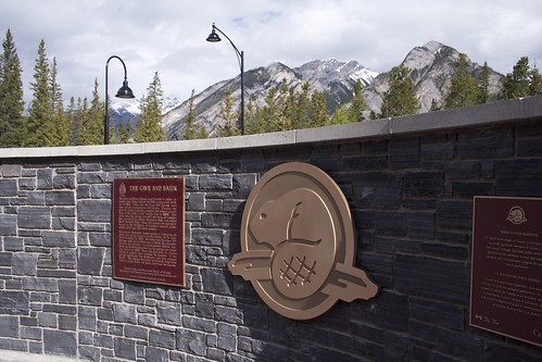
The Birth of Canada's National Parks

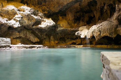
Cave & Basin - Birth of Canada's National Parks


Basically the Canadian Rockies are so beautiful that your 'to do' list could literally be simply 'look outside, wander around.'  But nonetheless, I was doing some research on things to see and do and came across the Cave and Basin National Historic Site - located in the town of Banff, it is the birthplace of Canada's National Parks system.  While working on the railway, three workers stumbled across a cave opening - had the guts to go inside despite the sulphur smell - and discovered a beautiful underground hot spring.  After the discovery came the plan - a plan to profit from this incredible place - sparking controversy over the ownership of the land, and in 1885 the Canadian government protected 26km2 of land, the Banff Hot Springs Reserve.  In 1887, the Rocky Mountains Park Act expanded the protected area to encompass 674km2 of land - Canada's first National Park, and the second in North America.  Banff National Park, along with Jasper, Kootenay and Yoho National Parks, Mount Robson, Mount Assiniboine, and Hamber Provincial Parks, are also a World Heritage Site.

The day of my visit called for rain - but as the weather changes quickly in the mountains, I was fortunate upon waking to find a beautifully clear day.  I made my way on foot the 2.5km to the Cave and Basin National Historic Site, meeting a mule deer on the side of the road along the way.  I arrived before the site itself opened, and so I wandered some of the outdoor trails - including the Discovery Trail and the Marsh Loop, both of which have lots of interesting information posted along them and offer stunning views of Cascade Mountain and Mount Norquay.  Finally, I was able to enter the site - which has a display about its history - and at last the cave.  Stunning.

Cave and Basin National Historic Site


Outside, you are able to view the Basin, another hot spring on the site.  There, I learned a bit about (and see, for real, live and in person) an endangered species, the Banff Springs Snail, the entire population of which apparently could fit in a 1L container.

The Cave and Basin National Historic Site has recently reopened after some major renovations and building improvements, and as I have at other National Historic Sites I found the Parks Canada staff friendly, welcoming, and informative.  It is well worth the stop.

Icefield Parkway and Athabasca Glacier

I've not done many organized tours in my limited travels, but after reading about the tour offered by Discover Banff Tours for the Columbia Icefield, I was convinced that this would be the way to see it.  Discover Banff Tours is a smaller tour company operating out of Banff, and I'm really happy I went with them - their tour size was small (about 14 people), their guide was experienced, friendly and knowledgeable, and their price was very reasonable ($159/person for a 10 hour tour, complete with picnic lunch and the ice field explorer tour).  Visit www.banftours.com to learn more about the other tour packages they offer.

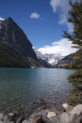
My morning started at 8:30 a.m. when a small tour van picked a few other guests and me up at the hotel.  From there, we made our way to a site in town where some other guests were waiting and we hopped on a larger (but still smaller than a greyhound, again nice tour size) bus with our guide for the day.  My tour had a few people from England, a couple from Ireland, some folks from Australia, another Canadian couple from Toronto, a woman from South Africa and another from Germany.  We were promptly whisked away to our first stop - Lake Louise.  Wow.


Lake Louise


We had a number of stops along our journey, while our tour guide told us about the history of the area - predominantly from the perspective of the tourism industry, guides and outfitters, the early settlers to the area and the families who's legacies are still evident throughout the town today.  We learned about the difference between a glacier and an icefield, and about the wildlife in the area.

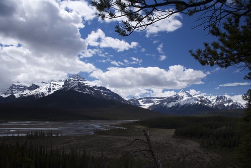
Our lunch stop was near Saskatchewan Crossing - where the North Saskatchewan River meets the Howse River and Mistaya River on its way to British Columbia.  Not a bad view for lunch, eh?


Saskatchewan River


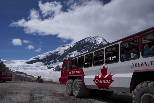
From there we weren't far from the Columbia Icefield - after arriving at the centre, we transferred first to a greyhound along with other tour groups and individuals, which would take us on the eight minute journey to the ice explorers at the edge of the Athabasca Glacier.  This eight minute ride is full of more information from another great guide - learning about the moraines, and what really stuck with me were the trees - all were very small, despite some being 300 years old - and others, in the distance, a remarkable 800 year old ancient forest.  The trees are so small due to such short growing seasons.  Also, there were areas where the trees only grew on one side - due to how cold the glacial winds are, freezing the sap in the trunks, stunting the growth.

We transferred to the Icefield Explorer - an industrial machine worth over $1M each (they have a whole fleet of them - the only similar machine not located in Banff National Park is trotting around Antarctica).  They are built especially to climb the incredibly steep moraine - basically wall of dirt and rock - at the side of the glacier.  It's an impressive piece of machinery, and again the guide was a delight.


Ice Explorer at Athabasca Glacier


Getting to walk around on a glacier - to touch the ice, to drink the water - is amazing.  The word one of my tour buddies, a lovely woman from South Africa used to describe what we were seeing, was "blessed."

Our ride back included some discussion about the environmental impact of these tour groups driving and walking on the glacier.  It was an interesting conversation, and I think it's a delicate balance that needs to be achieved in our national parks - a balance between preserving and protecting our land and our water, and providing people with the opportunity to experience and make use of these incredible places.  That access helps solidify a connection, and enhances your understanding of just what is at stake as our world changes.


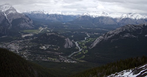
Banff Gondola - View of the Town of Banff, Tunnel Mountain and the Canadian Rockies


I left Banff feeling refreshed by the beauty of the land, and grateful for the chance to visit such a wonderful place.  I hope I'll get to visit again, but first there's still so much of Canada to explore...

Monday, 10 June 2013

Guest Bloggers (and Big Blog Exchange)

So with my recent trip being to Iceland, I did some research into things to do in and around Reykjavik (I love to do research.  I love scoring the 'net for cool and interesting things to do and see, off the beaten path).  All this research led me to "I Heart Reykjavik" - a very comprehensive guide of things to do, see, eat, stay, etc. in Reykjavik.  It's a wonderful blog if you're thinking of visiting Iceland, it's very resourceful, easy to read, and easy to navigate.

Anyway.

I follow the author on Twitter as well, thinking that that way I would know if/when she added something new to her blog, so I could check it out for any other helpful hints.  Currently, she is participating in "The Big Blog Exchange" - a competition run by Hostelling International, where readers voted for blosg, and the top 16 authors exchange blogs, and cities!, for 10 days.  They then write their thoughts, activities, impressions and ideas in the other person's blog.

I think it's a really cool idea.  And it got me thinking, of doing guest bloggers here.  I (unfortunately, alas) will never be able to visit all the places in this world (no matter how much I wish that were otherwise) so why not give someone else an outlet, to share their experiences? 

So in the next little bit, my friend Jessi will be a guest blogger, on her trip out west to Alberta.  My first guest blogger!  I'm pretty stoked.

Tuesday, 4 June 2013

Hiking the Adirondacks

For the past year and a half, I've been going down to the Adirondacks with a friend of mine, and we've been climbing various 46ers.  She had heard about the 46er club, told me about it as we climbed Mount Cascade and Mount Porter (see post about that here), and ever since...we've been working towards the goal of joining.

I really should have been keeping this updated on those hikes, for others who have the same goal.  I've been lax, what with my giant Africa trip, and then various little trips afterwards.  So I'll post a short summary of the ones we've done so far, excluding Cascade and Porter because I've hit those two.

Algonquin, Iroquois and Wright
Order in ranking: numbers 2, 8, and 16

Last year, we summitted Mounts Algonquin, Iroquois and Wright (on one day), and then Giant Mountain the next.

Our original plan was to hike (or as we call it, mountain-hike) Algonquin and Wright, as they share a path, with Wright a junction off of the main path up Algonquin.  But as we suited up at the car, a guide with the ADK offered us some advice: climb Iroquois as well.  It turns out that to get to Iroquois, you first must summit not only Algonquin, but also Boundary Mountain, between two.

This was one of our first lessons on attempting to call the 46 High Peaks:  do your research before you go.

With the Peak Steward


Algonquin is a nice climb, although there is a lot of sheer rock face at the end, and a few false summits.  We actually yelled out to the Peak Steward "Is this really the summit?!?" by the time we got there.  It's a little windy on the summit, so bring something to cut the wind.

Follow the cairns
Iroquois is a trailless peak, but all that means in this case is that the trail is not marked, and it's not officially maintained.  There is a herd path that you can easily follow; and down the side of Algonquin and up Boundary there are cairns marking the way - they're very easy to see and follow.  Once you get to Boundary, there's a small sign pointing the way to an official DEC path, and scratched into the sign is a arrow with the word "Iroquois."  (In case the scratched note is gone, you want to go in the opposite direction of the official path).  From there, you follow a path through the trees towards Iroquois.  The last bit is a mad scramble up a massive rock, to the summit of Iroquois.  I'm afraid of heights, and this scramble up did trigger that, so be forewarned.
Atop the rock to the summit
This rain cloud followed us all day
Back down we scrambled, after a very short stay - it looked like rain, and we didn't want to be caught out in the open on any of the peaks so far.  They're all (Algonquin, Boundary and Iroquois) open summits, with no trees for shelter.  We high-tailed it back to Algonquin at a pretty good clip, and stopped to enjoy the view from there one more time.  Then it was back down, to the junction with Wright.

We wheezed our way up Wright, and got caught by more false summits than I care to admit.  I think if we had saved Wright for another day, we could have been faster, but as it was we were exhausted.  We did make it to the summit, but not until after a lot of pep talks to ourselves.  We didn't even attempt to find the bronze plaque that commemorates the bomber that crashed there in 1962, we just too tired.
No, I'm done for the day.  Nap time.


Total hiking time: 9 hours and 33 minutes
Left Adirondack Loj at 9:20, returned at 6:53
Summited Algonquin at 12:32, Iroquois at 12:46, and Wright at 4:09


Giant Mountain
Order in ranking: number 12


We weren't up as early as we had wanted to be the day after, but in all fairness, we deserved a bit of a lie in.  We still made good time, though, as we got ready for another day of mountain-walking.


We had decided to climb Giant Mountain from the Roaring Brook trailhead, off of Hwy 73.  This is opposite to the trailhead for Nippletop, Dial, Colvin, Blake, and Lower Wolfjaw, if you intend to do it alone, and not as part of a loop with Armstrong, Gothics and Upper Wolfjaw.

This was a very pretty climb, with incredible views the entire way, and a moderate incline at the beginning.  Towards the end, it gets fairly steep, or so it felt to us.  There's a marker that announces it's only .7 mile to the summit of Giant, but that .7 mile felt like the longest .7 mile in the existence of history.

On the summit of Giant
The route was moderate in popularity - we saw a few other hikers, and met people at the summit, but often as not we had the path to ourselves.  This was a welcome relief after the day before, when we saw a lot of people out on the paths around the Adirondack Loj.

Seeing as it was so quiet, we actually did get to see some wildlife - a small snake was sunning himself beside the path on our way back down to the trailhead.


Total hiking time: 6 hours 14 minutes
Left the trailhead at 10:05, returned at 4:19
Summited at 1:18

Tabletop Mountain
Order in ranking: number 18

Later on in the fall, we had a plan to go down for a weekend, and climb Tabletop and Phelps Mountains (they share a trail, until a junction for Phelps) on one day, and Street and Nye (again, they share a trail) on the other.

But wouldn't you know it - it started to rain, as we pulled onto the road to get to the Adirondack Loj, where we were to camp.  We remained optimistic, as it was only a light drizzle, and set up our tent.  We went to sleep, hoping that the rain would abate before morning.  Our luck wasn't with us, and we awoke to full rain in the morning.  Still, we persevered, and got ready to tackle Tabletop and Phelps.

Wet start
We were late starting, as we had to register at the Loj, and get a few things together.  We started off, and immediately had problems.  It was wet, the trail was met and muddy, and it was slow going.  We pushed on, and tried to remain optimistic.  We staggered and pushed our way through the mud and trees, and finally got to the Tabletop junction.

Tabletop is an trailless peak, although the herd-path that you take to the summit is maintained somewhat.  It's easy to follow, for the simple reason that it's actually a streambed you're following.  And in the rain.....it's a stream.  You have to walk up and through the stream to get to the summit.  To compound our problems, because it's a trailless peak, the herd path is very narrow, with lots of trees (with their roots and branches) in your way.  My waterproof pants ended up ripped at the bottom from getting snagged one too many times.

We made it!  Finally!
We finally did reach the summit, but we were so worn out and tired, not to mention cranky and cold, that we didn't stay long.  It was long enough, though, for us to realize that we had least picked a good day to climb Tabletop - it's a treed summit, so there's no view.  We were happy not to have wasted a nice day with a summit that had no view.

We started to stagger our way down, still with the intention of climbing Phelps when disaster struck.  I slipped on the rock, and started to slide down - thankfully, still on the path, but I'd have a nice bruise on my backside the next day.  I picked myself up, swore, and continued on.  We reached the junction, and pushed up on Phelps.  We climbed for what seemed hours (actually, I think it was 2) and came to the realization that it was too late - we weren't going to summit Phelps that day.

Spirit still high, on the way up
This was our second lesson of hiking the 46ers:  Be prepared to turn around. 

And our third:  Plan for all eventualities; plan to hike two mountains, expect to only summit one.

We turned around, and started down, when disaster struck again.  Steph caught her foot in a root, and fell.  Hard.  She thankfully didn't break anything, but her leg was given a nasty jar, and she bruised (and possibly sprained) her thumb while catching herself on her fall.  We were extremely lucky that neither one of us hit a jagged rock or tree root when we fell.  We started back down at a slower pace, limping and in bad moods.


Total climbing time: unknown
Left Adirondack Loj at 9:45
Summited at 1:23


Phelps Mountain
Order in ranking: number 31


We had unfinished business with Phelps after our disastrous trip in mid-September.  We decided that we'd do the fool-hardy thing, and drive down from Ottawa early early (5 am early), climb Phelps, have some dinner at Desperados (fantastic Mexican food, with many gluten-free and vegetarian options), then drive back home.  It would make for a long day, but we were up for it.

Marcy Dam
We got onto the trail at a reasonable hour, and blew through the first portion, to Marcy Dam.  This is relatively flat terrain, and good for beginner hikers.  It's very pretty, and the Dam makes a nice backdrop for lunch.  We kept going, though, and quickly came to the Phelps junction.

Up we started.  It didn't take much time for us to come to the realization that it had been a good thing to turn back last time.  We were no where near the summit when we had turned around, and we probably wouldn't have made it back to the Loj before the sun set.

We kept going, and eventually reached the summit.  Phelps isn't a difficult climb, and if it hadn't been for the rain on our first trip, we would have summited it with no problems.  Reaching the summit, we were both glad that we had summitted on a better day, the view of the surround area was incredibly.  The nicer weather was definitely a boon, to actually get to take advantage of the view!

On the way down, we actually managed to find the root that had tripped Steph on our first attempt.  Considering everything looks the same after a bit (it was a root, on the trail, near a tree - very vague statement when everything is a root on the trail near a tree).  It was one of the few areas on the trail that didn't have a million jagged rocks that she could have fallen on.  Seeing it again, in the clear light of a sunny day, we thanked whoever had been looking out for us.  It really could have been a lot worse.

Total climbing time: 5 hours 49 minutes
Left Adirondack Loj at 10:20, returned at 4:09
Summited at 2:09

Lower Wolfjaw Mountain
Order in ranking: number 29


Misty Mountains
While I was in Africa, Steph took a few trips down to climb some of the other 46ers, Lower Wolfjaw and Big Slide.  While I still haven't had a change to climb Big Slide, and I did go down over the Thanksgiving (Canadian Thanksgiving) weekend to climb Lower Wolfjaw.  It was another somewhat wet climb - it drizzled on and off during the morning, but the rain cleared up in the afternoon, although it took a little longer for the clouds to dissipate.

The BF and I did this as a day trip, so we didn't get started until a little later, just after 10:00.  We were accessing the WA White trailhead on the AMR property, so we took a short jaunt up the road to the clubhouse (faaaaaancy), and turned left at the tennis court.  We quickly came to the trailhead and signed in.

Beautiful trees
The first part of the hike is incredibly beautiful, as you hike through birch stands.  The trail begins to do a bit of a zig zag up the mountain, as you climb around a rock wall.  It's not too steep, but it does add time to the climb.  We came to a few junctions, and it was at the final one, 1.5 miles to the summit, that I left the BF behind.  (It's not that I don't love him, but he's a computer geek.  He's not in the greatest of shapes.)

I quickly picked up the pace and raced towards what I hoped was the summit.  Every now and then I'd hit an open patch, and think "is this it??"  And it never was.  I finally met up with a group of people who said that the summit was a little further on.  So I continued, and....found the path going down.  I figured I had hit the summit, and returned.  When I met up with them again (in the same spot, as they were taking a break) they informed me that the trail actually descends quite steeply first, then climbs steeply before you hit the summit.

So heaving a great sigh.....I turned back and continued through the steep bits (with lots of "Ok, how will I climb/descend that???" thrown in for good measure).  I finally did hit the summit, along with three other hikers who had come in from Upper Wolfjaw.  They kindly took my photo, and I raced back, to find the BF.
Summit!
Who just so happened to be at the steep upper part!  He had made it that far, although his knee was starting to hurt, and it was getting late, so we decided we had better head back.

It was slow going on the way down, due to the BF's knee, and me totally forgetting that I had Advil in my pack.  But we did make it, a little later than we had hoped, but back alive and in one piece.

Total climbing time: 8 hours 22 minutes
Left trailhead at 10:14, returned at 6:36
Summited at 2:09

Nippletop and Dial
Order in ranking: numbers 13 and 40


Seriously?  It's the end of May
Nippletop and Dial were our first climbs of the 2013 "climbing season" as we call it.  We're fair weather hikers/campers - we firmly avoid the mountains in the winter months.  We thought by the May long weekend, it would be warm enough, and nice enough, to venture up.

It was and it wasn't.  We did encounter snow, although nothing that deep.  There were the odd occasions where we wondered if we needed crampons, but in the end we were fine in just our hiking boots.  It did pay to go carefully through the snow and ice, as occasionally the ice masqueraded as rock - all the dirt covering it was doing a good job at disguising it.

There are two possible ways to do the loop that we did - climb a steep, but non-treacherous path over the shoulder of Noonmark, over Dial, to Nippletop, and then descend over a very steep, rocky section, or the reverse.  I've found, after climbing 9 High Peaks, that it's over easier to climb up the rocky section, rather than down.  In essence, the rocky sections are where the mountain has fallen away/been pushed down by glaciers or water, so going up means you can see how the rocks fell.  It's much easier to find footing when you can see how the rocks interplay, then to descend these rocks, and how that interplay hidden.

So we walked down the Lake Road to Elk Pass, and up over Nippletop.  There are actually three or four steep bits, but the last steep bit is the steep bit that guide books warn you about.  It's not a bad hike though, and there's lots of waterfalls along the way, so no matter where you take a break, you get a view.  The trail was incredibly wet as we wet along, and I'm not sure how much of that was due to the wet spring weather, and melting snow.  Guide books mention that Nippletop is known for being wet (not weather-wise, trail-wise).

We met other hikers on the trail going to various peaks - Colvin, Blake, and Nippletop.  It was nice having company, especially so early in the season.  We reached what we thought was the summit of Nippletop when we realized.....it wasn't.  The trail kept going.  So we rounded a corner, and.....is that Nippletop?  Way over there?!?  We have to hike all the way over there?!?  The true summit seems forever away, when in fact it's a quick 3 minute hop over.  The distances can be very deceptive when you're looking over the range.
That looks really far away
We had a half hour break on Nippletop, admiring the view, before we headed out to Dial.  It's a great walk along the ridge line, to Dial.  There is some gentle grade up and down, which is a nice break after the scramble up Nippletop.  The summit for Dial comes up on you all of a sudden - it's a rocky outcropping from the trail.  More great views here, so you have a choice of where to have lunch - both summits afford a good look at many 46ers.
Hanging out over Nippletop

Dial summit
After Dial, we continued over Bear Den (it's a treed summit, so good luck figuring out where it is.  Also, no we didn't see a Bear Den.)  and down.  Well, down and then up, as the trail climbs over Noonmark's shoulder, before descending back down to the Lake Road.  The last bit is quite steep, but there aren't any rocks.  It's hard on the hips and knees, but there's no scrambling.

Total climbing time:9 hours 15 minutes
Left St. Hubert's parking lot at 7:18, returned at 4:33
Summited Nippletop at 10:40, Dial at 1:40


Whiteface and Esther
Order in ranking: numbers 5 and 27

We were up nice and early the next day, and drove the short distance to Whiteface mountain.  The parking lot for the trailhead is minuscule - about enough room for 2 cars.  It's easy to drive right past it, but you don't get far before realizing you're past it.

Can't miss the cairn
We were entering from the Wilmington trailhead, mostly because we wanted to climb Mt. Esther as well.  The first part of the hike was great - fairly flat, with moderate inclines/declines, through trees and few to no rocks.  But we quickly hit the steep portions, as we started climbing higher to the almost summit of Marble Mt.  It's a steady incline, somewhat steep, that will have you asking when the next flat bit will come along.

From there, we pushed on up towards the junction with Esther.  Again, it's a steady, moderately steep, incline to the cairn that marks the junction.  The guide books call it "small" but it certainly isn't - you can't miss it.  Esther is another trailless peak, but again, the herd path is moderately maintained and easy to follow.

The climb to Esther is easy, once you get past the first 100 yards or so, which are steep.  After that it's a gentle up and down grade, as you wind through the trees.   You almost feel like you are circling the summit as you come up to, and then it opens up and you get a great view of Whiteface.  There's a small plaque on the summit, for Esther McComb who made the first ascent. 

We paused for a moment, but other than the view of Whiteface, Esther doesn't provide much.  So we hustled back down, meeting a few other climbers on their way up.

We got back to the junction and paused for a food break.  I think we were hungrier on day two, after expending so much energy the day before!  Thankfully we had packed a lot of munching food for our climb.

You skirt this wall, you don't climb it
We headed up Whiteface, which at first was an easy, if somewhat wet, climb.  There were a lot of downed trees along our route - clean up crews hadn't been by to clear the trail, yet - so we had some manoeuvring to get over them.  We came upon a old ski lift area (or perhaps it's a ski run) and stopped to have some more food.  After that, it was steeply up as we followed old ski lines.  We went up up up, and then up some, over snow and ice at some points.  The trail was slick in places, especially as we came up over the rock scramble to the road, and wall surrounding it.

The rock scramble was fun going on, somewhat treacherous going down, as you couldn't see what was hidden by the rocks on the other side, as you could when you were going up.  The boost to get up to the path above the road was wet and slick, so we took our time.  After that, it was a moderate grade incline - not as steep as it had been, but certainly not as gentle as Esther had been.  We followed the paint blazes on the rocks, as we had hit the Alpine zone at this point.  There's a wonderful open area just below the summit, where you get great views of the surrounding countryside, and without all the other people like you do at the summit.  If the weather had been better (by this point, clouds had blown in) we might have stayed for a bit.  As it was, we pushed on.
Just beyond that wall is a highway

We staggered up to the summit, and had our picture taken with the sign.  All the tourist who drove up kindly let us go first.  We popped into the building at the top to warm up a little (Whiteface is always windy, but today it was freezing at the top), and regroup.

If you do climb Whiteface, don't forget your wallet.  There's a cafe at the top where you can grab food or water.  We both forgot ours, which led to our fourth lessons of climbing in the Adirondacks:

Always care money in backpack.  You never know when you might need it.

Made it!
We left the peak, and began the descent.  We were so focused on our conversation, that we both missed the open area where we had had our lunch.  Just towards the end of the hike, it started to rain, and we were very glad to have missed the rain at the summit.  The tree cover kept the rain mostly off us, so we didn't bother with pulling out our rain gear.

Total climbing time: 9 hours and 8 minutes
Left trailhead at 7:10, returned at 4:18
Summited Esther at 10:43, Whiteface at 12:55